
2023 Map of Ashley
USGS Topo · Published 2023About this map
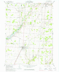
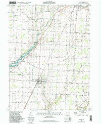
Ashley serves as a central hub in this southern Morrow and northern Delaware County landscape, where the agricultural grid is deeply etched by the winding course of Whetstone Creek and the West Branch Alum Creek. The geography is defined by a high concentration of localized burial grounds and historical places of worship, such as the Center Methodist Episcopal Ch and the Westfield Methodist Episcopal Cem. These sites, including the ancient Mounds Cem and the East Oxford Cem, suggest generations of settled rural life.
Find a feature on this map
99 named features on this map. Tap any name to fly to it.
Don’t see what you’re looking for? This feature index may not catch every label — zoom into the map to look around manually.
Map Details
Editions of this 2023 Ashley Map
This is the sole edition of this map. No revisions or reprints were ever made.
Historical Maps of Lincoln Township Through Time
3 maps found
Featured Locations
- Peru Township, OH
- Cardington Township, OH
- Ashley, Oxford Township
- Westfield, Westfield Township
- Cardington, Cardington Township