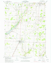
1961 Map of Ashley
USGS Topo · Published 1977About this map
Ashley serves as a central hub on this 1961 survey, situated along the New York Central railroad near the Ashley Union Cem and Richardson Airport. The landscape is defined by its transition between agricultural plateaus and the emerging waters of Lake Delaware, with the Delaware Wildlife Area marking the southwestern reaches. The map details a dense network of country roads like Waldo Ashley Road and West Liberty Road, connecting dispersed settlements such as Cardington, Shawtown, and West Liberty. Genealogical value is high here, with numerous small burial grounds including Gavitt Cem, Morehouse Cem, and Windfall Cem located near family-named intersections. The drainage pattern of Whetstone Creek and Alum Creek underscores the region's reliance on these waterways before and after the development of the reservoir.
Find a feature on this map
40 named features on this map. Tap any name to fly to it.
Don’t see what you’re looking for? This feature index may not catch every label — zoom into the map to look around manually.
Map Details
Editions of this 1961 Ashley Map
2 editions found
Other maps of this area

1903 · Marion
USGS Topo · 1:62,500

1905 · Marion
USGS Topo · 1:62,500

1913 · Mount Gilead
USGS Topo · 1:62,500

1915 · Marengo
USGS Topo · 1:62,500

1916 · Mount Gilead
USGS Topo · 1:62,500

1924 · Delaware
USGS Topo · 1:62,500

1925 · Delaware
USGS Topo · 1:62,500

1943 · Marengo
USGS Topo · 1:62,500

1943 · Mount Gilead
USGS Topo · 1:62,500

1944 · Delaware
USGS Topo · 1:62,500