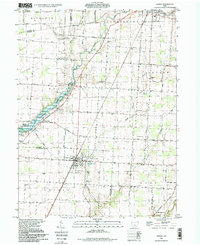
1995 Map of Ashley
USGS Topo · Published 1999About this map
The village of Ashley sits at the intersection of Morrow Co and Delaware Co in central Ohio, serving as a focal point for this agrarian landscape in the mid-1990s. The village is anchored by local infrastructure like the Waterworks and the Richardson Airport, while the Conrail line provides a north-south transit corridor through the heart of town. To the northwest, the terrain is defined by the Whetstone Creek valley and the upper reaches of the Delaware Reservoir, which feeds into the Delaware State Wildlife Area. This map documents a dense network of family and community history through its numerous burial grounds, such as Ashley Union Cem and the ancient Mounds Cem. Small rural settlements like Shawtown and Westfield are connected by a grid of historic routes, including the Cardington Treaty Road, reflecting a landscape deeply rooted in 19th-century treaty boundaries and early township divisions.
Find a feature on this map
59 named features on this map. Tap any name to fly to it.
Don’t see what you’re looking for? This feature index may not catch every label — zoom into the map to look around manually.
Map Details
Editions of this 1995 Ashley Map
This is the sole edition of this map. No revisions or reprints were ever made.
Other maps of this area

1903 · Marion
USGS Topo · 1:62,500

1905 · Marion
USGS Topo · 1:62,500

1913 · Mount Gilead
USGS Topo · 1:62,500

1915 · Marengo
USGS Topo · 1:62,500

1916 · Mount Gilead
USGS Topo · 1:62,500

1924 · Delaware
USGS Topo · 1:62,500

1925 · Delaware
USGS Topo · 1:62,500

1943 · Marengo
USGS Topo · 1:62,500

1943 · Mount Gilead
USGS Topo · 1:62,500

1944 · Delaware
USGS Topo · 1:62,500