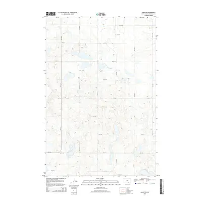
2014 Map of Ashley NE
USGS Topo · Published 2014About this map
George Cem sits on the high prairie north of Salt Lake, marking a distinct point of genealogy interest in this rural corner of McIntosh County. The landscape is defined by a complex network of wetlands and small kettle lakes characteristic of the Missouri Coteau region. A rigid grid of section-line roads, including 49th Ave SE and 81st St SE, provides the primary structure for the agricultural land use that dominates the area. Notable for its relative lack of major town sites, this map instead reveals the persistence of rural landmarks like Cr-2610 which serve as the lifelines for local farmsteads. The topographic contours highlight the undulating terrain, where subtle elevation changes dictate the location of local drainages and water bodies.
Find a feature on this map
18 named features on this map. Tap any name to fly to it.
Don’t see what you’re looking for? This feature index may not catch every label — zoom into the map to look around manually.
Map Details
Editions of this 2014 Ashley NE Map
This is the sole edition of this map. No revisions or reprints were ever made.
Other maps of this area

1953 · Jamestown
USGS Topo · 1:250,000

1956 · Jamestown
USGS Topo · 1:250,000

1982 · Coldwater Lake NW
USGS Topo · 1:24,000

1982 · Guyson
USGS Topo · 1:24,000

1982 · Danzig
USGS Topo · 1:24,000

1982 · Ashley East
USGS Topo · 1:24,000
1982 · Coldwater Lake SW
USGS Topo · 1:24,000

1982 · Ashley NE
USGS Topo · 1:24,000

1982 · Lehr SW
USGS Topo · 1:24,000
1982 · Ashley West
USGS Topo · 1:24,000