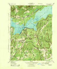
1943 Map of Ashokan
USGS Topo · Published 1944About this map
The Ashokan Reservoir dominates this wartime landscape, its massive footprint shaping the surrounding communities of Olive, Hurley, and Marbletown. Developed during an era of significant infrastructure expansion, the map reveals the complex water management system of the day, including the B WS Pump Station and specialized facilities like the Spillway School and Lower Spillway School. The New York Central rail line hugs the northern shore, connecting the mountain settlements of Shokan and Ashokan to the broader regional economy.
Find a feature on this map
35 named features on this map. Tap any name to fly to it.
Don’t see what you’re looking for? This feature index may not catch every label — zoom into the map to look around manually.
Map Details
Editions of this 1943 Ashokan Map
This is the sole edition of this map. No revisions or reprints were ever made.
Other maps of this area

1892 · Kaaterskill
USGS Topo · 1:62,500

1893 · Kaaterskill
USGS Topo · 1:62,500

1894 · Kaaterskill
USGS Topo · 1:62,500

1899 · Kaaterskill
USGS Topo · 1:62,500

1900 · Phoenicia
USGS Topo · 1:62,500

1901 · Rosendale
USGS Topo · 1:62,500

1903 · Rosendale
USGS Topo · 1:62,500

1903 · Phoenicia
USGS Topo · 1:62,500

1903 · Kaaterskill
USGS Topo · 1:62,500

1903 · Slide Mountain
USGS Topo · 1:62,500