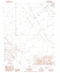
1987 Map of Ashton
USGS Topo · Published 1987About this map
Amargosa Desert terrain dominates this 1987 survey, characterized by the intermittent course of the Amargosa River and numerous mining interests. The map documents industrial and logistical activity through several prospects, a mine, and a gravel pit, alongside a prominent transmission line cutting across the arid landscape. The presence of the Ashton (Site) and the settlement of Lees suggests the sparse human footprint in this border region during the late 20th century.
Find a feature on this map
16 named features on this map. Tap any name to fly to it.
Don’t see what you’re looking for? This feature index may not catch every label — zoom into the map to look around manually.
Map Details
Editions of this 1987 Ashton Map
This is the sole edition of this map. No revisions or reprints were ever made.
Other maps of this area

1908 · Furnace Creek
USGS Topo · 1:250,000

1910 · Furnace Creek
USGS Topo · 1:250,000

1942 · Bullfrog
USGS Topo · 1:125,000

1948 · Death Valley
USGS Topo · 1:250,000

1952 · Chloride Cliff
USGS Topo · 1:50,000

1952 · Big Dune
USGS Topo · 1:62,500

1954 · Bare Mtn
USGS Topo · 1:62,500

1954 · Bullfrog
USGS Topo · 1:62,500

1954 · Death Valley
USGS Topo · 1:250,000

1956 · Death Valley
USGS Topo · 1:250,000