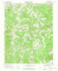
1968 Map of Aspen
USGS Topo · Published 1971About this map
Aspen and the surrounding tobacco-country ridges of Charlotte County are documented here in the late 1960s, defined by a landscape of small crossroads settlements and rural congregations. The Norfolk and Western railway cuts through the center of the sheet, providing a vital transport link for communities like Phenix and Camptown. Numerous country churches, such as Midway Ch, Mt Carmel Ch, and Aspen Hill Ch, serve as local anchors across the rolling terrain between Turnip Creek and Cub Creek. Along the southern boundary, the Roanoke River marks the border with Halifax County, while the interior is webbed with smaller waterways like Louse Creek and Temple Branch. This era shows the region as it transitioned with modern infrastructure, featuring a Gaging Sta and a noted Historic Monument near the river, reflecting a deep-rooted Virginia social fabric preserved before significant later development.
Find a feature on this map
29 named features on this map. Tap any name to fly to it.
Don’t see what you’re looking for? This feature index may not catch every label — zoom into the map to look around manually.
Map Details
Editions of this 1968 Aspen Map
This is the sole edition of this map. No revisions or reprints were ever made.
Other maps of this area

1892 · Appomattox
USGS Topo · 1:125,000

1947 · Roanoke
USGS Topo · 1:250,000

1953 · Greensboro
USGS Topo · 1:250,000

1954 · Greensboro
USGS Topo · 1:250,000

1954 · Clover
USGS Topo · 1:62,500

1954 · Halifax
USGS Topo · 1:62,500

1956 · Brookneal
USGS Topo · 1:62,500

1956 · Charlotte Court House
USGS Topo · 1:62,500

1959 · Roanoke
USGS Topo · 1:250,000

1962 · Greensboro
USGS Topo · 1:250,000