
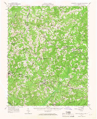
1956 Map of Charlotte Court House
USGS Topo · Published 1957About this map
Charlotte Court House serves as the focal point of this Southside Virginia landscape, situated where local roads converge near the Randolph-Henry Sch. The mid-century map illustrates a rural economy defined by small communities like Madisonville and Drakes Branch, connected by the steel of the Virginian and Norfolk and Western railroads. This era shows the region's agricultural depth, noted by the presence of the VPI Experimental Farm and several neighborhood mills such as Wards Fork Mill.
Find a feature on this map
92 named features on this map. Tap any name to fly to it.
Don’t see what you’re looking for? This feature index may not catch every label — zoom into the map to look around manually.
Map Details
Editions of this 1956 Charlotte Court House Map
2 editions found
Other maps of this area

1891 · Farmville
USGS Topo · 1:125,000

1892 · Appomattox
USGS Topo · 1:125,000

1893 · Farmville
USGS Topo · 1:125,000

1947 · Roanoke
USGS Topo · 1:250,000

1953 · Greensboro
USGS Topo · 1:250,000

1954 · Greensboro
USGS Topo · 1:250,000

1954 · Clover
USGS Topo · 1:62,500

1954 · Halifax
USGS Topo · 1:62,500

1955 · Chase City
USGS Topo · 1:62,500

1956 · Brookneal
USGS Topo · 1:62,500