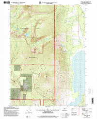
1998 Map of Aspen Lake
USGS Topo · Published 2000About this map
Aspen Lake anchors the eastern edge of this landscape, where the high terrain of the Southern Cascades transitions into the Winema National Forest. The map detail centers on the Mountain Lakes Wilderness, a glaciated volcanic upland dominated by a ring of peaks including Mount Harriman, Mount Carmine, and Loop Mountain Lakes. This high-altitude basin is dotted with numerous small alpine water bodies such as Coyote Lake, Lake Harriette, and Echo Lake, all connected by a network of paths like the Mountain Lakes Loop Trail. To the south, the massive profiles of Aspen Butte and Little Aspen Butte tower over the surrounding forest. The presence of a Gravel Pit and Cinder Pit near Buck Peak indicates the localized extraction of volcanic materials for forest road maintenance in this timber-rich region of Klamath County.
Find a feature on this map
31 named features on this map. Tap any name to fly to it.
Don’t see what you’re looking for? This feature index may not catch every label — zoom into the map to look around manually.
Map Details
Editions of this 1998 Aspen Lake Map
This is the sole edition of this map. No revisions or reprints were ever made.
Other maps of this area

1889 · Klamath
USGS Topo · 1:250,000

1891 · Ashland
USGS Topo · 1:250,000

1893 · Ashland
USGS Topo · 1:250,000

1894 · Klamath
USGS Topo · 1:250,000

1897 · Ashland
USGS Topo · 1:250,000

1955 · Lake O' Woods
USGS Topo · 1:62,500

1955 · Surveyor Mtn
USGS Topo · 1:62,500

1955 · Klamath Falls
USGS Topo · 1:250,000

1955 · Medford
USGS Topo · 1:250,000

1957 · Medford
USGS Topo · 1:250,000