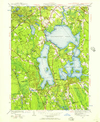
1948 Map of Assawompset Pond
USGS Topo · Published 1957About this map
The massive expanse of Assawompset Pond dominates this coastal lowland landscape, which in the late 1940s served as a critical hydraulic hub for the region. Public infrastructure like the Taunton Waterworks and New Bedford Waterworks highlight the importance of these interconnected glacial lakes, including Long Pond and Great Quittacas Pond, for municipal supply. The surrounding area reflects a quintessential southeastern Massachusetts mix of agriculture and transportation history, evidenced by the numerous specialized wetlands such as Bettys Neck Cranberry Bog and Fish Bogs. Local transit is transitioning, marked by the presence of the New Haven and Hartford RR alongside segments of the New Haven (Abandoned) Road. Small social clusters like South Lakeville and East Freetown are anchored by several historic family burial grounds, including the Strowbridge Cem and McCully Cem.
Find a feature on this map
97 named features on this map. Tap any name to fly to it.
Don’t see what you’re looking for? This feature index may not catch every label — zoom into the map to look around manually.
Map Details
Editions of this 1948 Assawompset Pond Map
This is the sole edition of this map. No revisions or reprints were ever made.
Other maps of this area

1885 · New Bedford
USGS Topo · 1:62,500

1885 · Middleboro
USGS Topo · 1:62,500

1885 · Taunton
USGS Topo · 1:62,500

1888 · New Bedford
USGS Topo · 1:62,500

1888 · Fall River
USGS Topo · 1:62,500

1888 · Taunton
USGS Topo · 1:62,500

1888 · Middleboro
USGS Topo · 1:62,500

1893 · Taunton
USGS Topo · 1:62,500

1893 · Middleboro
USGS Topo · 1:62,500

1893 · Fall River
USGS Topo · 1:62,500