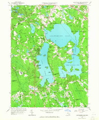
1963 Map of Assawompset Pond
USGS Topo · Published 1965About this map
Assawompset Pond and Long Pond anchor this landscape, representing a complex network of glacial lakes and reservoirs in southeastern Massachusetts. The 1963 revision of the 1937 topography reveals a post-war shift toward lakeside residential development, seen in the proliferation of seasonal and year-round communities like Buena Vista Shores, Churchill Shores, and Lakeview Heights. These shoreline neighborhoods contrast with the older, inland agricultural and cemetery-rich clusters at Precinct, East Freetown, and North Rochester.
Find a feature on this map
136 named features on this map. Tap any name to fly to it.
Don’t see what you’re looking for? This feature index may not catch every label — zoom into the map to look around manually.
Map Details
Editions of this 1963 Assawompset Pond Map
This is the sole edition of this map. No revisions or reprints were ever made.
Other maps of this area

1885 · New Bedford
USGS Topo · 1:62,500

1885 · Middleboro
USGS Topo · 1:62,500

1885 · Taunton
USGS Topo · 1:62,500

1888 · New Bedford
USGS Topo · 1:62,500

1888 · Fall River
USGS Topo · 1:62,500

1888 · Taunton
USGS Topo · 1:62,500

1888 · Middleboro
USGS Topo · 1:62,500

1893 · Taunton
USGS Topo · 1:62,500

1893 · Middleboro
USGS Topo · 1:62,500

1893 · Fall River
USGS Topo · 1:62,500