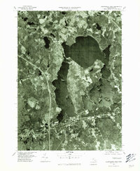
1977 Map of Assawompset Pond
USGS Topo · Published 1981About this map
Assawompset Pond and its interconnected neighbors dominate this 1977 aerial survey of southeastern Massachusetts. The orthophoto format reveals the precise shoreline geometries and forested buffer zones of this vital freshwater system, providing a clear view of the rural and suburban interface in Plymouth County during the late 1970s. The settlement of Lakeville sits at the northern edge of the waters, where the Nemasket River begins its northward trek toward Upper Four Corners.
Find a feature on this map
10 named features on this map. Tap any name to fly to it.
Don’t see what you’re looking for? This feature index may not catch every label — zoom into the map to look around manually.
Map Details
Editions of this 1977 Assawompset Pond Map
This is the sole edition of this map. No revisions or reprints were ever made.
Other maps of this area

1885 · New Bedford
USGS Topo · 1:62,500

1885 · Middleboro
USGS Topo · 1:62,500

1885 · Taunton
USGS Topo · 1:62,500

1888 · New Bedford
USGS Topo · 1:62,500

1888 · Fall River
USGS Topo · 1:62,500

1888 · Taunton
USGS Topo · 1:62,500

1888 · Middleboro
USGS Topo · 1:62,500

1893 · Taunton
USGS Topo · 1:62,500

1893 · Middleboro
USGS Topo · 1:62,500

1893 · Fall River
USGS Topo · 1:62,500