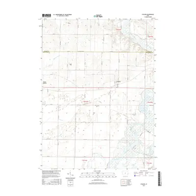
2015 Map of Atalissa
USGS Topo · Published 2015About this map
The Cedar River meanders through the eastern edge of this landscape, defining a wetland-rich corridor that includes Wiese Slough and Lindle Lake. The settlement of Atalissa sits near the center, while the eastern outskirts of West Liberty appear on the western margin. This area of eastern Iowa is characterized by a high concentration of water management features and family heritage sites, evidenced by the numerous drainage channels like Goshen Ditch, Wales Ditch, and Pike Run. Genealogists will find several notable burial grounds scattered across the rural township lines, including Gray's Ford Cem, Timberlake Cem, Weiss Cem, and Overman Cem. The terrain reflects a transition from organized agricultural fields to the intricate hydrologic networks of the river bottomlands, with small-scale landmarks such as Walker Field and the E Br Wapsinonoc Cr providing local orientation.
Find a feature on this map
67 named features on this map. Tap any name to fly to it.
Don’t see what you’re looking for? This feature index may not catch every label — zoom into the map to look around manually.
Map Details
Editions of this 2015 Atalissa Map
This is the sole edition of this map. No revisions or reprints were ever made.
Other maps of this area

1891 · Wilton Junction
USGS Topo · 1:62,500

1894 · West Liberty
USGS Topo · 1:62,500

1901 · Stanwood
USGS Topo · 1:125,000

1948 · Muscatine
USGS Topo · 1:62,500

1953 · Wilton Junction
USGS Topo · 1:24,000
1953 · Muscatine
USGS Topo · 1:24,000
1953 · Lime City
USGS Topo · 1:24,000

1958 · Davenport
USGS Topo · 1:250,000

1961 · Davenport
USGS Topo · 1:250,000

1962 · Davenport
USGS Topo · 1:250,000