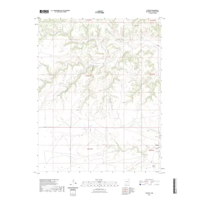
2023 Map of Atencio
USGS Topo · Published 2023About this map
Atencio sits in the high desert of northeastern Union County, where the plains give way to a complex network of eroded drainages. The landscape is defined by the winding course of Carrizozo Creek and the prominent Piñon Ridge, which overlooks a series of narrow cuts including Dry Canyon, Rodriguez Canyon, and Box Canyon. This 2023 survey provides a clear look at the sparse settlement patterns of the region, anchored by the local cemetery and isolated ranch roads. The presence of the Atencio Cem serves as a vital marker for genealogists, providing a permanent record of the families who inhabited this arid corner of New Mexico. The transition from mesa tops to canyon floors is mapped with precision, showing the rugged paths of Road Canyon and Trujillo Canyon as they navigate the breaks toward the southeastern corner of the quadrangle.
Find a feature on this map
20 named features on this map. Tap any name to fly to it.
Don’t see what you’re looking for? This feature index may not catch every label — zoom into the map to look around manually.
Map Details
Editions of this 2023 Atencio Map
This is the sole edition of this map. No revisions or reprints were ever made.
Other maps of this area

1954 · Dalhart
USGS Topo · 1:250,000

1958 · Dalhart
USGS Topo · 1:250,000

1962 · Dalhart
USGS Topo · 1:250,000

1972 · Seneca
USGS Topo · 1:24,000

1972 · Mc Laughlin Bridge
USGS Topo · 1:24,000
1972 · Wedding Cake Butte
USGS Topo · 1:24,000

1972 · Cuates School
USGS Topo · 1:24,000
1972 · Goodson School
USGS Topo · 1:24,000

1972 · Atencio
USGS Topo · 1:24,000

1972 · Moses
USGS Topo · 1:24,000