
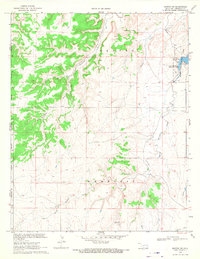
1972 Map of Moses
USGS Topo · Published 1975About this map
The Santa Fe Trail (Cimarron Cutoff) bisects this landscape along the border of New Mexico and Oklahoma, marking a historic corridor of western migration. Near the small settlement of Moses, several landmarks highlight the era of frontier travel and early ranching, including the Historical Marker Mc Ness Crossing and the distinctive Elephant Rock. The map is particularly useful for genealogical research, identifying local burial grounds such as Puertocito Cem, Moses Cem, and Rinker Cem.
Find a feature on this map
24 named features on this map. Tap any name to fly to it.
Don’t see what you’re looking for? This feature index may not catch every label — zoom into the map to look around manually.
Map Details
Editions of this 1972 Moses Map
This is the sole edition of this map. No revisions or reprints were ever made.
Other maps of this area

1954 · Dalhart
USGS Topo · 1:250,000

1958 · Dalhart
USGS Topo · 1:250,000

1962 · Dalhart
USGS Topo · 1:250,000

1969 · Felt SW
USGS Topo · 1:24,000

1969 · Wheeless
USGS Topo · 1:24,000
1969 · Kenton SW
USGS Topo · 1:24,000

1972 · Seneca
USGS Topo · 1:24,000

1972 · Atencio
USGS Topo · 1:24,000

1972 · Rardin Hill
USGS Topo · 1:24,000
1972 · Greendailey Canyon
USGS Topo · 1:24,000