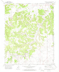
1972 Map of Greendailey Canyon
USGS Topo · Published 1975About this map
Greendailey sits at the heart of this high-plains landscape where the High Plains of Oklahoma meet the arid breaks of New Mexico. The terrain is defined by a dense network of drainages, including Huff Canyon and West Canyon, which cut through the uplifted Pinon Ridge. This 1972 field survey documents a working ranching environment where water access was the primary driver of settlement and land use. Isolated water sources such as Escondido Springs and Chet Springs are critical landmarks, supplemented by man-made improvements like the Piñon Windmill and Morledge Windmill.
Find a feature on this map
29 named features on this map. Tap any name to fly to it.
Don’t see what you’re looking for? This feature index may not catch every label — zoom into the map to look around manually.
Map Details
Editions of this 1972 Greendailey Canyon Map
This is the sole edition of this map. No revisions or reprints were ever made.
Other maps of this area

1954 · Dalhart
USGS Topo · 1:250,000

1958 · Dalhart
USGS Topo · 1:250,000

1962 · Dalhart
USGS Topo · 1:250,000

1968 · Kenton
USGS Topo · 1:24,000

1969 · Wheeless
USGS Topo · 1:24,000
1969 · Kenton SW
USGS Topo · 1:24,000

1972 · Seneca
USGS Topo · 1:24,000
1972 · Wedding Cake Butte
USGS Topo · 1:24,000
1972 · Goodson School
USGS Topo · 1:24,000

1972 · Atencio
USGS Topo · 1:24,000