1968 Map of Athens
USGS Topo · Published 1991About this map
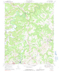
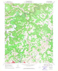
Concord College serves as a prominent landmark in the community of Athens, situated on the eastern ridges of this Mercer County landscape as it was documented in the late 1960s. The topography is defined by the winding course of the Bluestone River and its numerous tributaries, such as Camp Creek and Brush Creek. Significant transportation infrastructure of the era is evident, including the West Virginia Turnpike Toll Road cutting North-South through the center of the sheet and the Norfolk and Western railway corridor near Princeton. Local rural life is detailed through numerous small settlements like Spanishburg and Melrose, alongside scattered country churches including Painters Chapel and Pisgah Ch. The presence of Mercer Healing Springs and several rural schools like Silver Springs Sch highlights the social fabric of these mountain communities before modern consolidation altered the local geography.
Find a feature on this map
63 named features on this map. Tap any name to fly to it.
Don’t see what you’re looking for? This feature index may not catch every label — zoom into the map to look around manually.
Map Details
Editions of this 1968 Athens Map
2 editions found
Other maps of this area

1887 · Pocahontas
USGS Topo · 1:125,000

1887 · Hinton
USGS Topo · 1:125,000

1890 · Dublin
USGS Topo · 1:125,000

1891 · Pocahontas
USGS Topo · 1:125,000

1891 · Dublin
USGS Topo · 1:125,000

1891 · Raleigh
USGS Topo · 1:125,000

1892 · Hinton
USGS Topo · 1:125,000

1894 · Pocahontas
USGS Topo · 1:125,000

1895 · Pocahontas
USGS Topo · 1:125,000

1897 · Raleigh
USGS Topo · 1:125,000