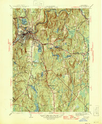
1946 Map of Athol
USGS Topo · Published 1946About this map
The Millers River corridor serves as the industrial and transit heart of this Worcester County region during the mid-1940s, anchored by the dense street grid of Athol. The Boston and Maine Railroad follows the river's winding path, connecting the manufacturing center to the broader Massachusetts rail network. Beyond the town center, the landscape transitions into a complex system of reservoirs and highlands, including Pratt Hill and Baldwin Hill. To the south, the Administration Bldg Harvard Forest marks a significant center for forestry research amidst the dense timber of Harvard Forest. Genealogists can find numerous burial grounds scattered across the townships, such as New Sherborn Cem and Lower Cem, which reflect the area's early settlement patterns. Rural life is further evidenced by isolated landmarks like the Phillipston No 1 Sch and the small cluster at Riceville, where Riceville Pond sits at the head of the Riceville Brook valley.
Find a feature on this map
58 named features on this map. Tap any name to fly to it.
Don’t see what you’re looking for? This feature index may not catch every label — zoom into the map to look around manually.
Map Details
Editions of this 1946 Athol Map
2 editions found
Other maps of this area

1887 · Warwick
USGS Topo · 1:62,500

1887 · Belchertown
USGS Topo · 1:62,500

1887 · Winchendon
USGS Topo · 1:62,500

1887 · Barre
USGS Topo · 1:62,500

1889 · Barre
USGS Topo · 1:62,500

1889 · Warwick
USGS Topo · 1:62,500

1890 · Belchertown
USGS Topo · 1:62,500

1890 · Winchendon
USGS Topo · 1:62,500

1893 · Belchertown
USGS Topo · 1:62,500

1894 · Winchendon
USGS Topo · 1:62,500