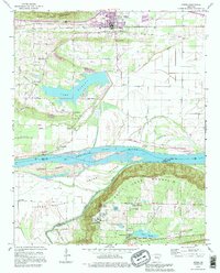
1989 Map of Atkins
USGS Topo · Published 1995About this map
The Arkansas River serves as the central artery for this region of central Arkansas, dividing the floodplain of Carden Bottom from the elevations of Carrion Crow Mountain. To the north, the town of Atkins is situated between Oak Creek and Kuhn Bayou, serving as a focal point for a landscape dotted with local heritage sites such as Bells Chapel Cem and Darr Cem. The creation of Atkins Lake and the presence of Galla Creek delineate the transition from the river valley to the rising timberlands.
Find a feature on this map
43 named features on this map. Tap any name to fly to it.
Don’t see what you’re looking for? This feature index may not catch every label — zoom into the map to look around manually.
Map Details
Editions of this 1989 Atkins Map
This is the sole edition of this map. No revisions or reprints were ever made.
Other maps of this area

1888 · Dardanelle #4
USGS Topo · 1:62,500

1888 · Dardanelle #1
USGS Topo · 1:62,500

1889 · Morrilton No. 3
USGS Topo · 1:62,500

1890 · Dardanelle
USGS Topo · 1:125,000

1892 · Morrillton
USGS Topo · 1:125,000

1894 · Morrillton
USGS Topo · 1:125,000

1956 · Russellville
USGS Topo · 1:250,000

1961 · Perryville
USGS Topo · 1:24,000

1961 · Morrilton West
USGS Topo · 1:24,000

1961 · Adona
USGS Topo · 1:24,000