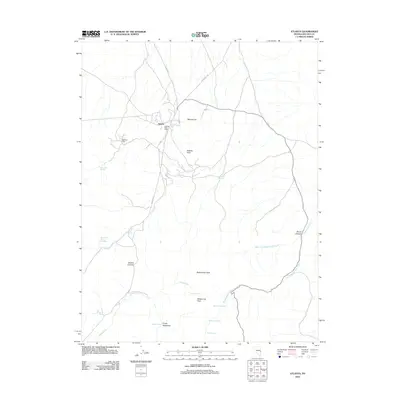
2012 Map of Atlanta
USGS Topo · Published 2012About this map
The settlement of Atlanta and its nearby Atlanta Post Office anchor this 2012 survey of eastern Nevada's high-desert mining and ranching country. The landscape is defined by its vital water sources and prominent landmarks like Mineral Hill and Atlanta Peak, which dominate the central terrain. Remote roads such as Atlanta RD and Hyde Well RD provide the primary access through this isolated portion of Lincoln County, where the economy was long tied to the minerals extracted from these peaks. To the south, Empy Meadows and Meadow Spring offer a contrast to the higher elevations of Atlanta Summit and Rosencrans Peak. The drainage network, including Wing Creek and Rosencrans Creek, flows through canyons like Smith Canyon, illustrating the importance of natural springs such as Silver Park Springs and Lizard Spring in this arid environment.
Find a feature on this map
26 named features on this map. Tap any name to fly to it.
Don’t see what you’re looking for? This feature index may not catch every label — zoom into the map to look around manually.
Map Details
Editions of this 2012 Atlanta Map
This is the sole edition of this map. No revisions or reprints were ever made.
Other maps of this area

1956 · Lund
USGS Topo · 1:250,000

1960 · Lund
USGS Topo · 1:250,000

1972 · Rosencrans Knolls
USGS Topo · 1:24,000

1972 · Hyde Well
USGS Topo · 1:24,000

1972 · Miller Canyon
USGS Topo · 1:24,000

1973 · Schoolmarm Basin
USGS Topo · 1:24,000

1973 · Horse Corral Pass
USGS Topo · 1:24,000

1973 · Atlanta
USGS Topo · 1:24,000
1973 · Trail Canyon
USGS Topo · 1:24,000
1973 · Wells Summit
USGS Topo · 1:24,000