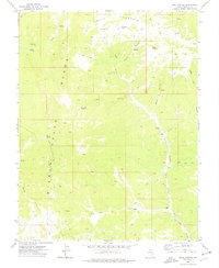
1973 Map of Trail Canyon
USGS Topo · Published 1977About this map
Table Mountain and the high ridges of the Wilson Creek Range define this high-altitude landscape in Lincoln County, where water is the primary driver of human settlement. Ranching operations like Big Jack Ranch and Donahue Ranch are established along the drainage of Camp Valley Creek, which serves as a vital corridor through the basin. The map reveals a network of natural water sources essential for livestock and survival in the Great Basin, including Bailey Springs, Pine Springs, and the isolated Mahogany Spring. Movement across the terrain is limited to a sparse system of primitive routes labeled simply as Jeep or Trail, connecting the high country to the valley floor. Evidence of range management appears in the form of several corrals and the Adams Reservoir, illustrating the functional requirements of high-desert agriculture in the 1970s.
Find a feature on this map
66 named features on this map. Tap any name to fly to it.
Don’t see what you’re looking for? This feature index may not catch every label — zoom into the map to look around manually.
Map Details
Editions of this 1973 Trail Canyon Map
This is the sole edition of this map. No revisions or reprints were ever made.
Other maps of this area

1956 · Lund
USGS Topo · 1:250,000

1960 · Lund
USGS Topo · 1:250,000
1970 · Mt. Wilson
USGS Topo · 1:24,000

1970 · Parsnip Peak
USGS Topo · 1:24,000

1972 · Rosencrans Knolls
USGS Topo · 1:24,000

1972 · Buck Wash Well
USGS Topo · 1:24,000

1972 · Miller Canyon
USGS Topo · 1:24,000

1973 · Schoolmarm Basin
USGS Topo · 1:24,000

1973 · Horse Corral Pass
USGS Topo · 1:24,000

1973 · Atlanta
USGS Topo · 1:24,000