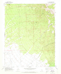
1970 Map of Mt. Wilson
USGS Topo · Published 1973About this map
Mount Wilson dominates the eastern high ground of this Lincoln County terrain, serving as a landmark for a landscape defined by seasonal water sources and early industry. The presence of Kilns and a Prospect suggests the localized mining and resource extraction that supported the region's scattered inhabitants during the mid-20th century. Numerous vital water points including Motley Spring, Eagle Spring, and Tottery Spring are mapped along the slopes leading down toward the broad expanse of Lake Valley. A series of interconnected routes, labeled as Jeep Trails, trace the path through Water Canyon and Hulse Canyon, reflecting the era's reliance on rugged transportation networks to reach high-altitude points like the Radio Tower and family-named landmarks such as Squaw Knoll.
Find a feature on this map
19 named features on this map. Tap any name to fly to it.
Don’t see what you’re looking for? This feature index may not catch every label — zoom into the map to look around manually.
Map Details
Editions of this 1970 Mt. Wilson Map
2 editions found
Other maps of this area

1915 · Bristol Range
USGS Topo · 1:62,500

1917 · Bristol Range
USGS Topo · 1:62,500

1953 · Bristol Range SE
USGS Topo · 1:24,000

1956 · Lund
USGS Topo · 1:250,000

1960 · Lund
USGS Topo · 1:250,000
1970 · Mt. Wilson SW
USGS Topo · 1:24,000

1970 · Pierson Summit
USGS Topo · 1:24,000

1970 · Parsnip Peak
USGS Topo · 1:24,000
1971 · Bristol Range NE
USGS Topo · 1:24,000

1973 · Schoolmarm Basin
USGS Topo · 1:24,000