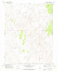
1970 Map of Mt. Wilson SW
USGS Topo · Published 1973About this map
Lake Valley provides the topographic setting for this 1970 field check of the Mt. Wilson SW quadrangle. The landscape is defined by the drainage patterns of Patterson Wash and the ephemeral flows of Hulse Creek and Page Creek. Human activity in this arid Lincoln County terrain is primarily marked by isolated water sources and industrial extraction points. The presence of Eightmile Well, Sixmile Well, and Benchland Well indicates the critical importance of groundwater for ranching or survival in the high desert. Scattered evidence of mineral exploration and material harvesting appears via a designated Prospect and a Gravel Pit, while a network of Jeep Trail routes provides the only visible infrastructure through the basin and range territory.
Find a feature on this map
12 named features on this map. Tap any name to fly to it.
Don’t see what you’re looking for? This feature index may not catch every label — zoom into the map to look around manually.
Map Details
Editions of this 1970 Mt. Wilson SW Map
This is the sole edition of this map. No revisions or reprints were ever made.
Other maps of this area

1885 · Pioche
USGS Topo · 1:250,000

1886 · Pioche
USGS Topo · 1:250,000

1915 · Bristol Range
USGS Topo · 1:62,500

1916 · Highland
USGS Topo · 1:62,500

1917 · Bristol Range
USGS Topo · 1:62,500

1918 · Highland
USGS Topo · 1:62,500

1921 · NW 1/4 Panaca
USGS Topo · 1:48,000

1953 · Highland Peak
USGS Topo · 1:24,000

1953 · Bristol Range SE
USGS Topo · 1:24,000

1953 · Pioche
USGS Topo · 1:24,000