
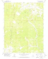
1972 Map of Miller Canyon
USGS Topo · Published 1975About this map
The White Rock Mountains and the eastern fringes of Hamlin Valley define this portion of Lincoln County during the early 1970s. The landscape is a network of intermittent drainages and isolated water sources, essential for the remote ranching operations located here. Small-scale human presence is anchored by Johnson Ranch and Deimje Ranch, connected by a web of unimproved trails and rugged paths through the high desert. The reliance on natural water sources is evident in the naming of numerous features like Rattlesnake Spring and Seven Troughs Spring, which likely supported livestock and early travelers.
Find a feature on this map
23 named features on this map. Tap any name to fly to it.
Don’t see what you’re looking for? This feature index may not catch every label — zoom into the map to look around manually.
Map Details
Editions of this 1972 Miller Canyon Map
This is the sole edition of this map. No revisions or reprints were ever made.
Other maps of this area

1956 · Lund
USGS Topo · 1:250,000

1960 · Lund
USGS Topo · 1:250,000

1970 · Parsnip Peak
USGS Topo · 1:24,000

1972 · Gleason Basin
USGS Topo · 1:24,000

1972 · Rosencrans Knolls
USGS Topo · 1:24,000

1972 · Hamlin Well
USGS Topo · 1:24,000

1972 · White Rock Peak
USGS Topo · 1:24,000

1972 · Buck Wash Well
USGS Topo · 1:24,000

1973 · Atlanta
USGS Topo · 1:24,000
1973 · Trail Canyon
USGS Topo · 1:24,000