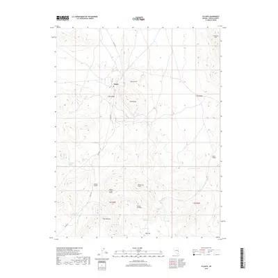
2018 Map of Atlanta
USGS Topo · Published 2018About this map
Atlanta sits at the heart of this high-desert landscape in Lincoln County, nestled between the Wilson Creek Range and the high summits of Atlanta Peak and Atlanta Summit. This 2018 survey reveals a terrain defined by its water sources, where numerous named springs like Silver Park Springs, Moonshine Spring, and Lizard Spring punctuate the arid environment. The primary artery, Atlanta Rd, provides access through the high country, skirting the base of Mineral Hill and leading south toward the expansive Empy Meadows.
Find a feature on this map
29 named features on this map. Tap any name to fly to it.
Don’t see what you’re looking for? This feature index may not catch every label — zoom into the map to look around manually.
Map Details
Editions of this 2018 Atlanta Map
This is the sole edition of this map. No revisions or reprints were ever made.
Other maps of this area

1956 · Lund
USGS Topo · 1:250,000

1960 · Lund
USGS Topo · 1:250,000

1972 · Rosencrans Knolls
USGS Topo · 1:24,000

1972 · Hyde Well
USGS Topo · 1:24,000

1972 · Miller Canyon
USGS Topo · 1:24,000

1973 · Schoolmarm Basin
USGS Topo · 1:24,000

1973 · Horse Corral Pass
USGS Topo · 1:24,000

1973 · Atlanta
USGS Topo · 1:24,000
1973 · Trail Canyon
USGS Topo · 1:24,000
1973 · Wells Summit
USGS Topo · 1:24,000