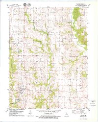
1979 Map of Atlanta
USGS Topo · Published 1979About this map
The Norfolk And Western railroad corridor anchors the landscape of northern Macon County in this late 1970s survey, passing directly through the community of Atlanta. This area is characterized by the branching drainages of the Middle Fork Salt River, where several smaller waterways like Willow Branch and Bee Branch carve into the agricultural terrain. The map captures several rural focal points, including the small settlement of Economy and the localized importance of Mt Tabor Ch and its adjacent Mt Tabor Cem. To the south, the Atlanta State Wildlife Area and Atlanta City Lake highlight the integration of water management and conservation within the township boundaries of Lyda and Jackson. For family historians, the presence of localized burial sites such as Hardgrove Cem and Shiloh Cem provide specific points of reference for tracing early resident lineages in this part of Missouri.
Find a feature on this map
21 named features on this map. Tap any name to fly to it.
Don’t see what you’re looking for? This feature index may not catch every label — zoom into the map to look around manually.
Map Details
Editions of this 1979 Atlanta Map
This is the sole edition of this map. No revisions or reprints were ever made.
Other maps of this area

1903 · Edina
USGS Topo · 1:125,000

1908 · Atlanta
USGS Topo · 1:62,500

1937 · Elmer
USGS Topo · 1:48,000

1938 · Kirksville
USGS Topo · 1:62,500

1940 · Kirksville
USGS Topo · 1:62,500

1942 · Elmer
USGS Topo · 1:62,500

1953 · Moberly
USGS Topo · 1:250,000

1954 · Centerville
USGS Topo · 1:250,000

1954 · Moberly
USGS Topo · 1:250,000

1957 · Moberly
USGS Topo · 1:250,000