
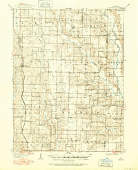
1908 Map of Atlanta
USGS Topo · Published 1908About this map
The Wabash RR cuts through the western Missouri prairie in this 1908 topographical study, serving the shipping needs of Atlanta and the surrounding agricultural townships. The landscape is a network of small family-centered rural hubs, many of which are anchored by a school or church every few miles. Notable local landmarks like Union Hall and Sue City appear alongside a high density of educational sites including La Porte School, Browns School No 5, and the Whiteoak School.
Find a feature on this map
66 named features on this map. Tap any name to fly to it.
Don’t see what you’re looking for? This feature index may not catch every label — zoom into the map to look around manually.
Map Details
Editions of this 1908 Atlanta Map
2 editions found
Other maps of this area

1903 · Edina
USGS Topo · 1:125,000

1908 · Macon
USGS Topo · 1:62,500

1910 · Macon
USGS Topo · 1:62,500

1937 · Elmer
USGS Topo · 1:48,000

1938 · Kirksville
USGS Topo · 1:62,500

1940 · Kirksville
USGS Topo · 1:62,500

1942 · Elmer
USGS Topo · 1:62,500

1953 · Moberly
USGS Topo · 1:250,000

1953 · Bevier South
USGS Topo · 1:24,000

1954 · Centerville
USGS Topo · 1:250,000