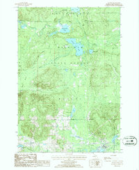
1986 Map of Atlanta
USGS Topo · Published 1986About this map
Atlanta serves as the focal point for this mid-1980s look at Montmorency County, situated at the confluence of Twin Lake and the Thunder Bay River. The surrounding landscape is dominated by the dense Montmorency State Forest, where numerous glacial lakes such as Valentine Lake, Muskellunge Lake, and Bear Lake dot the wooded terrain. This era of land management is evidenced by the established Clear Lake State Park and the extensive High Country Pathway trail system.
Find a feature on this map
29 named features on this map. Tap any name to fly to it.
Don’t see what you’re looking for? This feature index may not catch every label — zoom into the map to look around manually.
Map Details
Editions of this 1986 Atlanta Map
This is the sole edition of this map. No revisions or reprints were ever made.
Other maps of this area

1949 · Lewiston
USGS Topo · 1:62,500

1950 · Lewiston
USGS Topo · 1:24,000

1951 · Lewiston
USGS Topo · 1:24,000

1954 · Hetherton
USGS Topo · 1:62,500

1954 · Traverse City
USGS Topo · 1:250,000

1955 · Atlanta
USGS Topo · 1:62,500

1955 · Comins
USGS Topo · 1:62,500

1955 · Cheboygan
USGS Topo · 1:250,000

1958 · Cheboygan
USGS Topo · 1:250,000

1958 · Traverse City
USGS Topo · 1:250,000