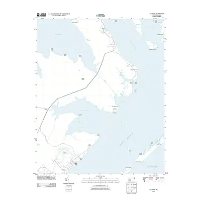
2011 Map of Atlantic
USGS Topo · Published 2011About this map
The coastal communities of Atlantic, Roe, and Lupton define the eastern edge of Carteret County, where the mainland gives way to the vast waters of the Core Sound. This maritime landscape is shaped by intricate waterways like Thorofare Bay and Rumley Bay, connected by the narrow John Ditch. The presence of the Atlantic Post Office and Atlantic Field marks the center of local activity, while Morris Marina and the Ira Morris Camp underscore the region's enduring ties to the sound and the Atlantic Ocean beyond.
Find a feature on this map
50 named features on this map. Tap any name to fly to it.
Don’t see what you’re looking for? This feature index may not catch every label — zoom into the map to look around manually.
Map Details
Editions of this 2011 Atlantic Map
This is the sole edition of this map. No revisions or reprints were ever made.
Other maps of this area

1948 · North Bay
USGS Topo · 1:24,000

1949 · Atlantic
USGS Topo · 1:24,000

1949 · Styron Bay
USGS Topo · 1:24,000

1949 · Point Of Marsh
USGS Topo · 1:24,000

1949 · Long Bay
USGS Topo · 1:24,000

1949 · Davis
USGS Topo · 1:24,000

1950 · Long Bay
USGS Topo · 1:24,000

1950 · North Bay
USGS Topo · 1:24,000

1950 · Point Of Marsh
USGS Topo · 1:24,000
1951 · Atlantic
USGS Topo · 1:24,000