1949 Map of Atlantic
USGS Topo · Published 1972About this map
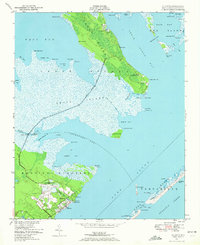
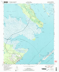
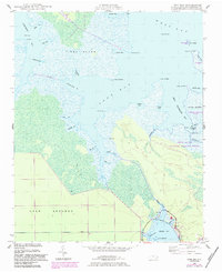
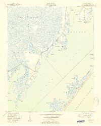
Cedar Island dominates this coastal survey, where the remote settlements of Roe and Lola were connected by a narrow road running the length of the marshy interior. These communities, alongside the village of Atlantic, relied on a complex network of waterways including West Bay and Thorofare Bay. The landscape is defined by its transition from mainland marsh to the outer reaches of Portsmouth Banks, with family and community history anchored at the Roe School, Freewill Church, and small burial sites like Gilgo Cem.
Find a feature on this map
71 named features on this map. Tap any name to fly to it.
Don’t see what you’re looking for? This feature index may not catch every label — zoom into the map to look around manually.
Map Details
Editions of this 1949 Atlantic Map
2 editions found
Other maps of this area

1948 · North Bay
USGS Topo · 1:24,000
1949 · Styron Bay
USGS Topo · 1:24,000
1949 · Point Of Marsh
USGS Topo · 1:24,000
1949 · Long Bay
USGS Topo · 1:24,000
1949 · Davis
USGS Topo · 1:24,000
1950 · Long Bay
USGS Topo · 1:24,000

1950 · North Bay
USGS Topo · 1:24,000

1950 · Point Of Marsh
USGS Topo · 1:24,000
1951 · Atlantic
USGS Topo · 1:24,000
1951 · Davis
USGS Topo · 1:24,000