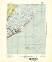
1941 Map of Atlantic City
USGS Topo · Published 1941About this map
Atlantic City's famous shoreline boardwalk and pier infrastructure dominate this coastal landscape just as the nation entered World War II. The map meticulously details the dense urban grid of the resort city, noting landmark structures like the Absecon Light and a series of grand amusement piers extending into the Atlantic Ocean, including the Steel Pier and Youngs Million Dollar Pier. These structures represented the pinnacle of early 20th-century seaside tourism, served by the Pennsylvania-Reading Seashore Lines which brought visitors directly to the coast.
Find a feature on this map
58 named features on this map. Tap any name to fly to it.
Don’t see what you’re looking for? This feature index may not catch every label — zoom into the map to look around manually.
Map Details
Editions of this 1941 Atlantic City Map
2 editions found
Other maps of this area

1884 · Sea Isle
USGS Topo · 1:62,500

1887 · Atlantic City
USGS Topo · 1:62,500

1888 · Little Egg Harbor
USGS Topo · 1:62,500

1888 · Sea Isle
USGS Topo · 1:62,500

1888 · Long Beach
USGS Topo · 1:62,500

1890 · Great Egg Harbor
USGS Topo · 1:62,500

1890 · Mullica
USGS Topo · 1:62,500

1893 · Great Egg Harbor
USGS Topo · 1:62,500

1893 · Little Egg Harbor
USGS Topo · 1:62,500

1893 · Long Beach
USGS Topo · 1:62,500
Featured Places
- Egg Harbor Township, NJ
- Atlantic City, NJ
- Galloway Township, NJ
- Little Egg Harbor Township, NJ
- Pleasantville, NJ