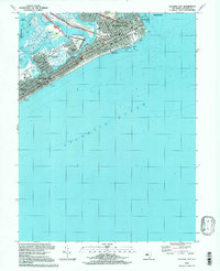
1994 Map of Atlantic City
USGS Topo · Published 1998About this map
Atlantic City and its legendary shoreline are documented here in the mid-1990s, showcasing the dense urban grid between the Boardwalk and the intricate back-bay waterways. The map illustrates a transitional era for the resort town, featuring the iconic Steel Pier, Steeplechase Pier, and the Ocean One Shopping Mall extending into the Atlantic Ocean. The presence of Bader Field and the Convention Hall highlights the city's role as a major regional hub for travel and events.
Find a feature on this map
44 named features on this map. Tap any name to fly to it.
Don’t see what you’re looking for? This feature index may not catch every label — zoom into the map to look around manually.
Map Details
Editions of this 1994 Atlantic City Map
This is the sole edition of this map. No revisions or reprints were ever made.
Other maps of this area

1884 · Sea Isle
USGS Topo · 1:62,500

1887 · Atlantic City
USGS Topo · 1:62,500

1888 · Sea Isle
USGS Topo · 1:62,500

1890 · Great Egg Harbor
USGS Topo · 1:62,500

1893 · Great Egg Harbor
USGS Topo · 1:62,500

1894 · Sea Isle
USGS Topo · 1:62,500

1894 · Atlantic City
USGS Topo · 1:62,500

1918 · Great Egg Harbor
USGS Topo · 1:62,500

1919 · Sea Isle
USGS Topo · 1:62,500

1940 · Atlantic City
USGS Topo · 1:62,500