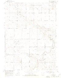
1951 Map of Atwood NE
USGS Topo · Published 1975About this map
The agricultural and industrial landscape of Logan County is defined here by the extensive irrigation network supporting the eastern Colorado plains. The North Sterling Canal and Pawnee Ditch serve as vital infrastructure, following the natural contours of the terrain alongside a series of levees. Rural life in the mid-century is marked by educational hubs such as the Mt Hope School in the north and the Pleasant Divide School further south, while the Drive-in Theater near the southern boundary reflects the era's social culture. Resource extraction is a prominent theme, with numerous Oil Wells and Gravel Pits scattered across the land between the drainages of Springdale Creek and Sand Creek. The map provides a precise record of these features following 1951 surveys, illustrating a period where water management and energy production were the primary drivers of local development.
Find a feature on this map
13 named features on this map. Tap any name to fly to it.
Don’t see what you’re looking for? This feature index may not catch every label — zoom into the map to look around manually.
Map Details
Editions of this 1951 Atwood NE Map
2 editions found
Other maps of this area

1951 · Willard
USGS Topo · 1:24,000

1951 · Sterling South
USGS Topo · 1:24,000

1951 · Sterling North
USGS Topo · 1:24,000

1951 · Wild Horse Lake
USGS Topo · 1:24,000

1951 · Atwood NE
USGS Topo · 1:24,000

1951 · Atwood
USGS Topo · 1:24,000

1952 · Padroni
USGS Topo · 1:24,000

1954 · Sterling
USGS Topo · 1:250,000

1958 · Sterling
USGS Topo · 1:250,000
1978 · North Sterling Reservoir
USGS Topo · 1:24,000