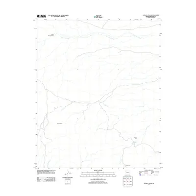
2011 Map of Aubrey Peak
USGS Topo · Published 2011About this map
Aubrey Peak and Groom Peak dominate this arid landscape in Mohave County, where the terrain is defined by a complex network of ephemeral drainages. The map records a geography shaped by seasonal water movement, most notably along Natural Corrals Wash and Bronco Creek. In the northeast, Cedar Mine Rd provides one of the few named transportation corridors through the area, hinting at the region's historical mining activity. The presence of Shannon Basin and numerous canyons, such as Stove Spring Canyon, illustrates a deeply eroded environment where water, though scarce, has been the primary architect of the land. This 2011 survey serves as a modern record of these high-desert features, capturing the remote character of the Western Arizona highlands before any significant contemporary development.
Find a feature on this map
9 named features on this map. Tap any name to fly to it.
Don’t see what you’re looking for? This feature index may not catch every label — zoom into the map to look around manually.
Map Details
Editions of this 2011 Aubrey Peak Map
This is the sole edition of this map. No revisions or reprints were ever made.
Other maps of this area

1923 · Signal
USGS Topo · 1:250,000

1942 · Signal
USGS Topo · 1:250,000

1950 · Prescott
USGS Topo · 1:250,000

1954 · Prescott
USGS Topo · 1:250,000

1958 · Prescott
USGS Topo · 1:250,000

1959 · Prescott
USGS Topo · 1:250,000

1960 · Prescott
USGS Topo · 1:250,000

1965 · Prescott
USGS Topo · 1:250,000
1967 · Groom Spring
USGS Topo · 1:24,000
1967 · Dutch Flat SE
USGS Topo · 1:24,000