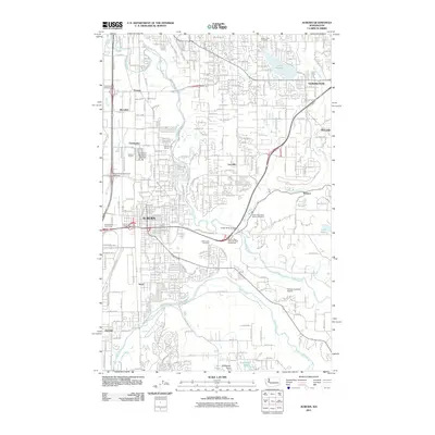
2011 Map of Auburn
USGS Topo · Published 2011About this map
Auburn and its surrounding valleys are defined by the convergence of the Green River and the White River, a landscape deeply shaped by river management and transportation corridors. This 2011 survey captures the area during a period of established suburban growth, showing the residential expansion across Lea Hill and into Covington and Berrydale. The map preserves the locations of older community identities such as Christopher, Thomas, and Meredith, which are now integrated into the larger metropolitan fabric. For those researching local heritage, the map identifies significant landmarks like the Suise Creek Cemetery and White Lake Cemetery, along with the Green River State Salmon Hatchery and the Emerald Downs racing facility. The presence of both the Auburn Municipal Airport and the Auburn Academy Airport underscores the importance of regional aviation in this part of King County, while the naming of Stuck River Dr serves as a reminder of the historical river diversion in the Stuck area.
Find a feature on this map
33 named features on this map. Tap any name to fly to it.
Don’t see what you’re looking for? This feature index may not catch every label — zoom into the map to look around manually.
Map Details
Editions of this 2011 Auburn Map
This is the sole edition of this map. No revisions or reprints were ever made.
Other maps of this area

1897 · Tacoma
USGS Topo · 1:125,000

1900 · Tacoma
USGS Topo · 1:125,000

1941 · Tacoma South
USGS Topo · 1:62,500

1942 · Lake Tapps
USGS Topo · 1:62,500

1944 · Lake Tapps
USGS Topo · 1:62,500

1944 · Tacoma South
USGS Topo · 1:62,500

1949 · Maple Valley
USGS Topo · 1:24,000

1949 · Black Diamond
USGS Topo · 1:24,000

1949 · Poverty Bay
USGS Topo · 1:24,000

1949 · Renton
USGS Topo · 1:24,000