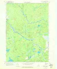
1970 Map of Augerhole Falls
USGS Topo · Published 1972About this map
The West Branch St Regis River winds through this heavily forested section of the Adirondack State Park near the intersection of Hopkinton, Waverly, and Altamont. In the early 1970s, the landscape remained largely defined by water and primitive access, centered on remote outposts like Wolf Pond Camp and Augerhole Camp. The geography is characterized by numerous small ponds and lakes, including Amber Lake, Jordan Lake, and Wolf Pond, connected by a network of named brooks and inlets. Navigation across the terrain relied heavily on a series of marked trails and jeep trails, reflecting the area's preservation as part of the State Forest Preserve. Notable hydraulic features such as Augerhole Falls and High Falls mark the descent of the river system, providing landmarks for local exploration and woodcraft in this wilderness corridor.
Find a feature on this map
38 named features on this map. Tap any name to fly to it.
Don’t see what you’re looking for? This feature index may not catch every label — zoom into the map to look around manually.
Map Details
Editions of this 1970 Augerhole Falls Map
This is the sole edition of this map. No revisions or reprints were ever made.
Other maps of this area

1905 · Saint Regis
USGS Topo · 1:62,500

1919 · Nicholville
USGS Topo · 1:62,500

1920 · Childwold
USGS Topo · 1:62,500

1921 · Childwold
USGS Topo · 1:48,000

1921 · Nicholville
USGS Topo · 1:62,500

1921 · Santa Clara
USGS Topo · 1:62,500

1922 · Childwold
USGS Topo · 1:62,500

1923 · Santa Clara
USGS Topo · 1:62,500

1948 · Ogdensburg
USGS Topo · 1:250,000

1951 · Ogdensburg
USGS Topo · 1:250,000