
1921 Map of Childwold
USGS Topo · Published 1921About this map
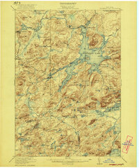
Raquette River rapids and waterfalls dominate this 1921 landscape as it descends through the Adirondack wilderness. The map captures a transition point where early tourism and logging outposts like Childwold and Sevey supported travelers near the Shurtleff Hotel. Small pockets of community life are visible at the Childwold School, Sevey School, and Hollywood School, while the interior remains defined by private camps and clubs, such as Kildare Club No 16. The terrain is characterized by a dense network of water bodies, including Joe Indian Pond and Amber Lake, many of which were accessed only by the primitive Kildare Road. To the east, the prominent Mt Matumbla rises above the marshy lowlands of the Jordan river valley, illustrating the challenging topography that shaped early settlement patterns in St. Lawrence and Franklin counties.
Find a feature on this map
82 named features on this map. Tap any name to fly to it.
Don’t see what you’re looking for? This feature index may not catch every label — zoom into the map to look around manually.
Map Details
Editions of this 1921 Childwold Map
This is the sole edition of this map. No revisions or reprints were ever made.
Other maps of this area

1904 · Long Lake
USGS Topo · 1:62,500

1905 · Saint Regis
USGS Topo · 1:62,500

1907 · Tupper Lake
USGS Topo · 1:62,500

1908 · Potsdam
USGS Topo · 1:62,500

1919 · Nicholville
USGS Topo · 1:62,500

1919 · Cranberry Lake
USGS Topo · 1:62,500

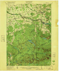
1920 · Childwold
USGS Topo · 1:62,500
1921 · Cranberry Lake
USGS Topo · 1:62,500
1921 · Nicholville
USGS Topo · 1:62,500
1921 · Stark
USGS Topo · 1:62,500