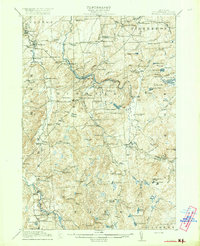
1921 Map of Stark
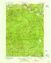
USGS Topo · Published 1956About this map
Stark and the winding Raquette River anchor this 1920s landscape in St. Lawrence County, partly situated within the Adirondack Park. The map reveals an area defined by early 20th-century industry and leisure, where the Lumber RR and Glendale Mill operated alongside private sporting retreats like the Massawepie Club, Hollywood Club, and Stillwater Club. Local life is visible in the scattered settlements of Sellecks Cors and Newbridge, supported by rural institutions including Cold Brook School and Clare School.
Find a feature on this map
95 named features on this map. Tap any name to fly to it.
Don’t see what you’re looking for? This feature index may not catch every label — zoom into the map to look around manually.
Map Details
Editions of this 1921 Stark Map
2 editions found

Other maps of this area

1907 · Tupper Lake
USGS Topo · 1:62,500

1908 · Potsdam
USGS Topo · 1:62,500

1910 · Canton
USGS Topo · 1:62,500

1911 · Canton
USGS Topo · 1:62,500

1915 · Russell
USGS Topo · 1:62,500

1916 · Oswegatchie
USGS Topo · 1:62,500
1918 · Russell
USGS Topo · 1:62,500

1918 · Oswegatchie
USGS Topo · 1:62,500

1919 · Nicholville
USGS Topo · 1:62,500

1919 · Cranberry Lake
USGS Topo · 1:62,500