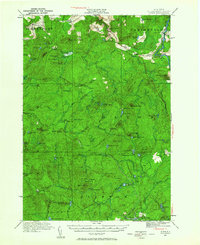
1921 Map of Stark
USGS Topo · Published 1964About this map
Stark and the Irish Settlement anchor the northern reaches of this Adirondack landscape as it appeared in the early 1920s. The region is defined by the complex waterways of the Grass River and Raquette River, where industrial and social footprints are visible at Gleasons Mill and the Stillwater Club. Local education is distributed across rural outposts like Littlejohn School, Cold Brook School, and Clare School, serving the scattered communities of Pierrepont and Colton.
Find a feature on this map
88 named features on this map. Tap any name to fly to it.
Don’t see what you’re looking for? This feature index may not catch every label — zoom into the map to look around manually.
Map Details
Editions of this 1921 Stark Map
2 editions found

Other maps of this area

1907 · Tupper Lake
USGS Topo · 1:62,500

1908 · Potsdam
USGS Topo · 1:62,500

1910 · Canton
USGS Topo · 1:62,500

1911 · Canton
USGS Topo · 1:62,500

1915 · Russell
USGS Topo · 1:62,500

1916 · Oswegatchie
USGS Topo · 1:62,500

1918 · Russell
USGS Topo · 1:62,500

1918 · Oswegatchie
USGS Topo · 1:62,500

1919 · Nicholville
USGS Topo · 1:62,500

1919 · Cranberry Lake
USGS Topo · 1:62,500