
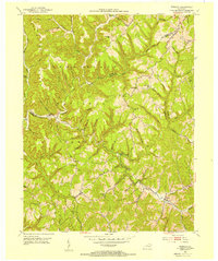
1950 Map of Ault
USGS Topo · Published 1952About this map
The hills of Elliott and Rowan Counties are defined by an intricate network of narrow hollows and ridge-top settlements in the mid-twentieth century. Small communities like Ordinary and Beartown serve as focal points for a rural landscape where life followed the winding paths of Big Caney Creek and Laurel Fork. The map reveals a high density of neighborhood institutions, with numerous one-room schoolhouses such as Clay Fork Sch and Mauk Sch scattered throughout the valleys, reflecting a era of localized education before widespread consolidation.
Find a feature on this map
57 named features on this map. Tap any name to fly to it.
Don’t see what you’re looking for? This feature index may not catch every label — zoom into the map to look around manually.
Map Details
Editions of this 1950 Ault Map
This is the sole edition of this map. No revisions or reprints were ever made.
Other maps of this area

1929 · Morehead
USGS Topo · 1:48,000

1935 · Morehead
USGS Topo · 1:62,500

1950 · Bruin
USGS Topo · 1:24,000

1950 · Grahn
USGS Topo · 1:24,000

1950 · Isonville
USGS Topo · 1:24,000

1950 · Olive Hill
USGS Topo · 1:24,000

1950 · Sandy Hook
USGS Topo · 1:24,000

1951 · Soldier
USGS Topo · 1:24,000

1953 · Haldeman
USGS Topo · 1:24,000
1953 · Wrigley
USGS Topo · 1:24,000