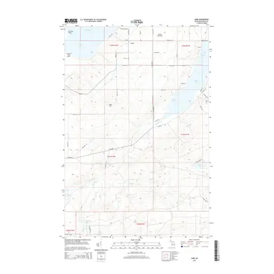
2014 Map of Aura
USGS Topo · Published 2014About this map
Aura serves as the central hub of this coastal Michigan landscape, situated on the western side of the Abbaye Peninsula where it meets Lake Superior. The area is defined by a dense network of local roads such as Windy Harbor Rd, Saari Rd, and Heikkinen Rd, reflecting the Finnish heritage of the settlers who established this community. To the south, the terrain rises toward Pikes Peak, and the drainage basin of the Silver River creates several notable water features, including Silver Falls and Middle Silver River Falls. Genealogists and local historians will find value in the location of the Aura Cem, while the shoreline reveals a series of protected inlets from Sand Bay to Echo Harbor. The presence of many family-named roads like Biltonen Rd and Haataja Rd suggests the enduring footprint of individual homesteads across the townships.
Find a feature on this map
58 named features on this map. Tap any name to fly to it.
Don’t see what you’re looking for? This feature index may not catch every label — zoom into the map to look around manually.
Map Details
Editions of this 2014 Aura Map
This is the sole edition of this map. No revisions or reprints were ever made.
Other maps of this area

1954 · Skanee
USGS Topo · 1:62,500

1954 · Keweenaw Bay
USGS Topo · 1:62,500

1955 · Herman
USGS Topo · 1:62,500

1956 · Michigamme
USGS Topo · 1:62,500

1958 · Iron River
USGS Topo · 1:250,000

1960 · Iron River
USGS Topo · 1:250,000

1961 · Iron River
USGS Topo · 1:250,000

1967 · Iron River
USGS Topo · 1:250,000
1984 · Skanee North
USGS Topo · 1:24,000
1984 · Aura
USGS Topo · 1:24,000