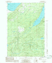
1984 Map of Aura
USGS Topo · Published 1985About this map
The Abbaye Peninsula extends into the cold waters of Lake Superior, defining the coastal character of this Upper Peninsula landscape. Much of the southern and central terrain is occupied by the L'Anse Indian Reservation, where the Silver River carves its way toward the coast, dropping over Silver Falls before reaching Keweenaw Bay. The small community of Aura serves as the primary settlement on the peninsula, connected by local routes like Kallio Road.
Find a feature on this map
28 named features on this map. Tap any name to fly to it.
Don’t see what you’re looking for? This feature index may not catch every label — zoom into the map to look around manually.
Map Details
Editions of this 1984 Aura Map
This is the sole edition of this map. No revisions or reprints were ever made.
Other maps of this area

1954 · Skanee
USGS Topo · 1:62,500

1954 · Keweenaw Bay
USGS Topo · 1:62,500

1955 · Herman
USGS Topo · 1:62,500

1956 · Michigamme
USGS Topo · 1:62,500

1958 · Iron River
USGS Topo · 1:250,000

1960 · Iron River
USGS Topo · 1:250,000

1961 · Iron River
USGS Topo · 1:250,000

1967 · Iron River
USGS Topo · 1:250,000
1984 · Skanee North
USGS Topo · 1:24,000
1984 · Portage Entry
USGS Topo · 1:24,000