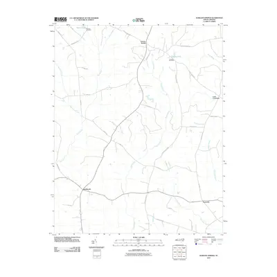
2010 Map of Aurelian Springs
USGS Topo · Published 2010About this map
Aurelian Springs and Brinkleyville anchor this landscape in rural Halifax County, where a complex network of slow-moving water systems defines the local geography. The area is characterized by expansive drainage basins, most notably Bear Swamp, Rocky Swamp, and the southern reaches of Burnt Coat Swamp. These natural features are interspersed with small-scale water management structures like the Warrens Pond Dam and Crawleys Pond Dam, indicating a long history of utilizing these wetlands for local needs.
Find a feature on this map
34 named features on this map. Tap any name to fly to it.
Don’t see what you’re looking for? This feature index may not catch every label — zoom into the map to look around manually.
Map Details
Editions of this 2010 Aurelian Springs Map
This is the sole edition of this map. No revisions or reprints were ever made.
Other maps of this area

1953 · Norfolk
USGS Topo · 1:250,000

1961 · Enfield
USGS Topo · 1:24,000

1963 · Ringwood
USGS Topo · 1:24,000

1963 · Essex
USGS Topo · 1:24,000

1973 · Aurelian Springs
USGS Topo · 1:24,000

1973 · Hollister
USGS Topo · 1:24,000
1973 · Thelma
USGS Topo · 1:24,000
1973 · Littleton
USGS Topo · 1:24,000
1974 · Roanoke Rapids
USGS Topo · 1:24,000

1974 · Darlington
USGS Topo · 1:24,000