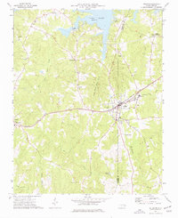
1973 Map of Littleton
USGS Topo · Published 1977About this map
Littleton sits at the heart of this North Carolina landscape, where the Seaboard Coast Line tracks bisect the town as they run between Vaughan and Cooleys Crossroads. To the north, the waters of Lake Gaston define the boundary of Warren Co and Halifax Co, reflecting a period when reservoir development reshaped the local geography. The map documents a deeply rooted rural community, marked by numerous congregations including Roanoke Chapel, St Annas Ch, and Weavers Chapel.
Find a feature on this map
33 named features on this map. Tap any name to fly to it.
Don’t see what you’re looking for? This feature index may not catch every label — zoom into the map to look around manually.
Map Details
Editions of this 1973 Littleton Map
This is the sole edition of this map. No revisions or reprints were ever made.
Other maps of this area

1919 · White Plains
USGS Topo · 1:48,000

1920 · White Plains
USGS Topo · 1:62,500

1953 · Norfolk
USGS Topo · 1:250,000

1953 · Greensboro
USGS Topo · 1:250,000

1954 · Greensboro
USGS Topo · 1:250,000

1962 · Greensboro
USGS Topo · 1:250,000

1963 · Gasburg
USGS Topo · 1:24,000

1963 · Valentines
USGS Topo · 1:24,000

1966 · Greensboro
USGS Topo · 1:250,000

1968 · South Hill SE
USGS Topo · 1:24,000