
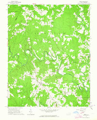
1963 Map of Essex
USGS Topo · Published 1964About this map
Fishing Creek and its tributary Little Fishing Creek carve a winding course through this rural landscape at the meeting point of Halifax, Nash, and Warren Counties. The area is defined by a deep-rooted network of country churches and family cemeteries, suggesting a stable agrarian community in the early 1960s. Small settlements like Essex and Aventon serve as local hubs, while smaller nodes like Ita appear near established landmarks. The economy shows clear ties to the land beyond farming, evidenced by the Brickyards along the creek and a Claypit north of Powells Creek. Topographic detail reveals a land dissected by numerous swamps, including White Oak Swamp and Gideon Swamp, which frame the upland ridges where the majority of homesteads and churches, such as Walters Chapel, were established. This survey captures the transition of eastern North Carolina before major modern development, where light-duty roads and field lines still trace the boundaries of old farmsteads.
Find a feature on this map
35 named features on this map. Tap any name to fly to it.
Don’t see what you’re looking for? This feature index may not catch every label — zoom into the map to look around manually.
Map Details
Editions of this 1963 Essex Map
2 editions found
Other maps of this area

1953 · Norfolk
USGS Topo · 1:250,000

1953 · Greensboro
USGS Topo · 1:250,000

1954 · Greensboro
USGS Topo · 1:250,000

1962 · Greensboro
USGS Topo · 1:250,000

1963 · Ringwood
USGS Topo · 1:24,000

1963 · Red Oak
USGS Topo · 1:24,000

1963 · Drake
USGS Topo · 1:24,000

1966 · Greensboro
USGS Topo · 1:250,000

1971 · Inez
USGS Topo · 1:24,000

1973 · Aurelian Springs
USGS Topo · 1:24,000