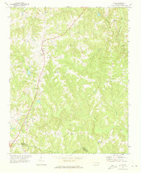
1971 Map of Inez
USGS Topo · Published 1973About this map
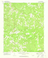
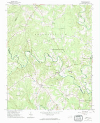
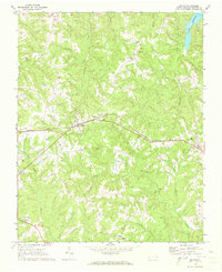
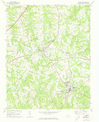
The crossroads of Inez and Liberia serve as focal points in this 1970s topographic study of the Warren County landscape. A network of rural roads connects established small settlements like Marmaduke and Grove Hill, revealing a community structure built around several country churches and family burial grounds. The land is defined by an intricate drainage system including Fishing Creek, Shocco Creek, and numerous branches like Wolfpit Branch and Maple Branch, which snake through the varied elevations. Social and spiritual centers are clearly marked, including Shady Grove Ch, Lovely Hill Ch, and Sarepta Ch. Positioned on a prominent rise near Liberia, a Lookout Tower provides a strategic vantage point over the timbered terrain and creek valleys that characterize this part of North Carolina.
Find a feature on this map
24 named features on this map. Tap any name to fly to it.
Don’t see what you’re looking for? This feature index may not catch every label — zoom into the map to look around manually.
Map Details
Editions of this 1971 Inez Map
This is the sole edition of this map. No revisions or reprints were ever made.
Other maps of this area

1953 · Norfolk
USGS Topo · 1:250,000

1953 · Greensboro
USGS Topo · 1:250,000

1954 · Greensboro
USGS Topo · 1:250,000

1962 · Greensboro
USGS Topo · 1:250,000
1963 · Essex
USGS Topo · 1:24,000

1966 · Greensboro
USGS Topo · 1:250,000
1970 · Macon
USGS Topo · 1:24,000
1970 · Warrenton
USGS Topo · 1:24,000
1971 · Afton
USGS Topo · 1:24,000
1973 · Hollister
USGS Topo · 1:24,000