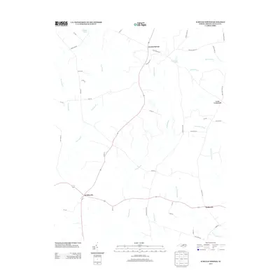
2013 Map of Aurelian Springs
USGS Topo · Published 2013About this map
Aurelian Springs and the surrounding rural communities of Halifax County are defined by an intricate network of wetlands and family-named landmarks. The landscape is dominated by the sprawling headwaters of the Bear Swamp, Rocky Swamp, and Beaverdam Swamp, which dictate the winding paths of local thoroughfares like Aurelian Springs Rd and Heathsville Rd. Small settlements such as Brinkleyville, Heathsville, and Lewis Crossroads serve as the primary hubs within this agricultural and hydrologic mosaic.
Find a feature on this map
44 named features on this map. Tap any name to fly to it.
Don’t see what you’re looking for? This feature index may not catch every label — zoom into the map to look around manually.
Map Details
Editions of this 2013 Aurelian Springs Map
This is the sole edition of this map. No revisions or reprints were ever made.
Other maps of this area

1953 · Norfolk
USGS Topo · 1:250,000

1961 · Enfield
USGS Topo · 1:24,000

1963 · Ringwood
USGS Topo · 1:24,000

1963 · Essex
USGS Topo · 1:24,000

1973 · Aurelian Springs
USGS Topo · 1:24,000

1973 · Hollister
USGS Topo · 1:24,000
1973 · Thelma
USGS Topo · 1:24,000
1973 · Littleton
USGS Topo · 1:24,000
1974 · Roanoke Rapids
USGS Topo · 1:24,000

1974 · Darlington
USGS Topo · 1:24,000