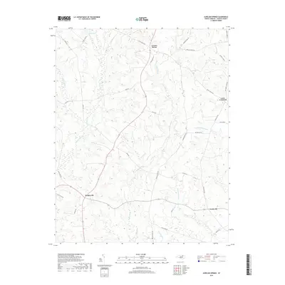
2019 Map of Aurelian Springs
USGS Topo · Published 2019About this map
Aurelian Springs and the surrounding rural communities of Halifax County define this landscape of low-lying wetlands and winding country roads. The area is characterized by an extensive network of named drainages, including the massive Bear Swamp and the meandering Rocky Swamp, which dictate the placement of local thoroughfares like Sledge Rd and Airlie Rd. These water systems, including Jacket Swamp and Beaverdam Swamp, highlight the challenges of coastal plain topography where settlement patterns cluster on higher ground at intersections like Brinkleyville and Lewis Crossroads.
Find a feature on this map
36 named features on this map. Tap any name to fly to it.
Don’t see what you’re looking for? This feature index may not catch every label — zoom into the map to look around manually.
Map Details
Editions of this 2019 Aurelian Springs Map
This is the sole edition of this map. No revisions or reprints were ever made.
Other maps of this area

1953 · Norfolk
USGS Topo · 1:250,000

1961 · Enfield
USGS Topo · 1:24,000

1963 · Ringwood
USGS Topo · 1:24,000

1963 · Essex
USGS Topo · 1:24,000

1973 · Aurelian Springs
USGS Topo · 1:24,000

1973 · Hollister
USGS Topo · 1:24,000
1973 · Thelma
USGS Topo · 1:24,000
1973 · Littleton
USGS Topo · 1:24,000
1974 · Roanoke Rapids
USGS Topo · 1:24,000

1974 · Darlington
USGS Topo · 1:24,000