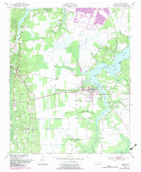
1950 Map of Aurora
USGS Topo · Published 1984About this map
Aurora serves as the central hub of this coastal North Carolina landscape, where the South Creek meets a complex network of wetlands and tributaries. The settlement pattern is deeply connected to the waterways and the Norfolk Southern rail line, which passes through Guilford Station and Edward. A striking density of country churches and family burial grounds, such as Weeping Rachel Ch, St Peter Ch, and the Bonner Cem, reflects a well-established rural community fabric. The geography is defined by broad swampy tracts like Beacham Savanna and Fan Swamp, while the shoreline along the creeks is dotted with named points including Jewell Point and Deephole Pt. By the time of this survey, an Old Railroad Grade and a riverside Landing Strip indicate shifting modes of transport and industry near the Beaufort County coast.
Find a feature on this map
56 named features on this map. Tap any name to fly to it.
Don’t see what you’re looking for? This feature index may not catch every label — zoom into the map to look around manually.
Map Details
Editions of this 1950 Aurora Map
4 editions found
Other maps of this area

1950 · Vandemere
USGS Topo · 1:24,000

1950 · South Creek
USGS Topo · 1:24,000

1950 · Aurora
USGS Topo · 1:24,000

1950 · Edward
USGS Topo · 1:24,000

1951 · Bath
USGS Topo · 1:24,000

1951 · Ransomville
USGS Topo · 1:24,000

1953 · Blounts Bay
USGS Topo · 1:24,000

1953 · Rocky Mount
USGS Topo · 1:250,000

1954 · Rocky Mount
USGS Topo · 1:250,000
1968 · Bayboro
USGS Topo · 1:24,000