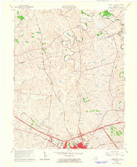
1965 Map of Austerlitz
USGS Topo · Published 1966About this map
Winchester serves as the focal point of activity on this mid-1960s survey, positioned where the Louisville and Nashville railroad corridors and the emerging Mountain Parkway intersect. The landscape is defined by the winding paths of Strodes Creek and Green Creek, with rural life clustered around older crossings like Austerlitz and Renick. Suburban growth is evident in developments such as Victory Heights, Bel Air, and Meadowbrook, which contrast with the surrounding agricultural land delineated by fence and field lines.
Find a feature on this map
35 named features on this map. Tap any name to fly to it.
Don’t see what you’re looking for? This feature index may not catch every label — zoom into the map to look around manually.
Map Details
Editions of this 1965 Austerlitz Map
This is the sole edition of this map. No revisions or reprints were ever made.
Other maps of this area

1892 · Richmond
USGS Topo · 1:125,000

1897 · Richmond
USGS Topo · 1:125,000

1927 · Lexington
USGS Topo · 1:48,000

1929 · Lexington
USGS Topo · 1:62,500

1952 · Paris East
USGS Topo · 1:24,000

1952 · Clintonville
USGS Topo · 1:24,000

1952 · Austerlitz
USGS Topo · 1:24,000

1952 · North Middletown
USGS Topo · 1:24,000

1952 · Ford
USGS Topo · 1:24,000

1952 · Winchester
USGS Topo · 1:24,000